


Text:
LAND USE CHANGE
US Army Corps of Engineers
Lake Shelbyville and the Kaskaskia River
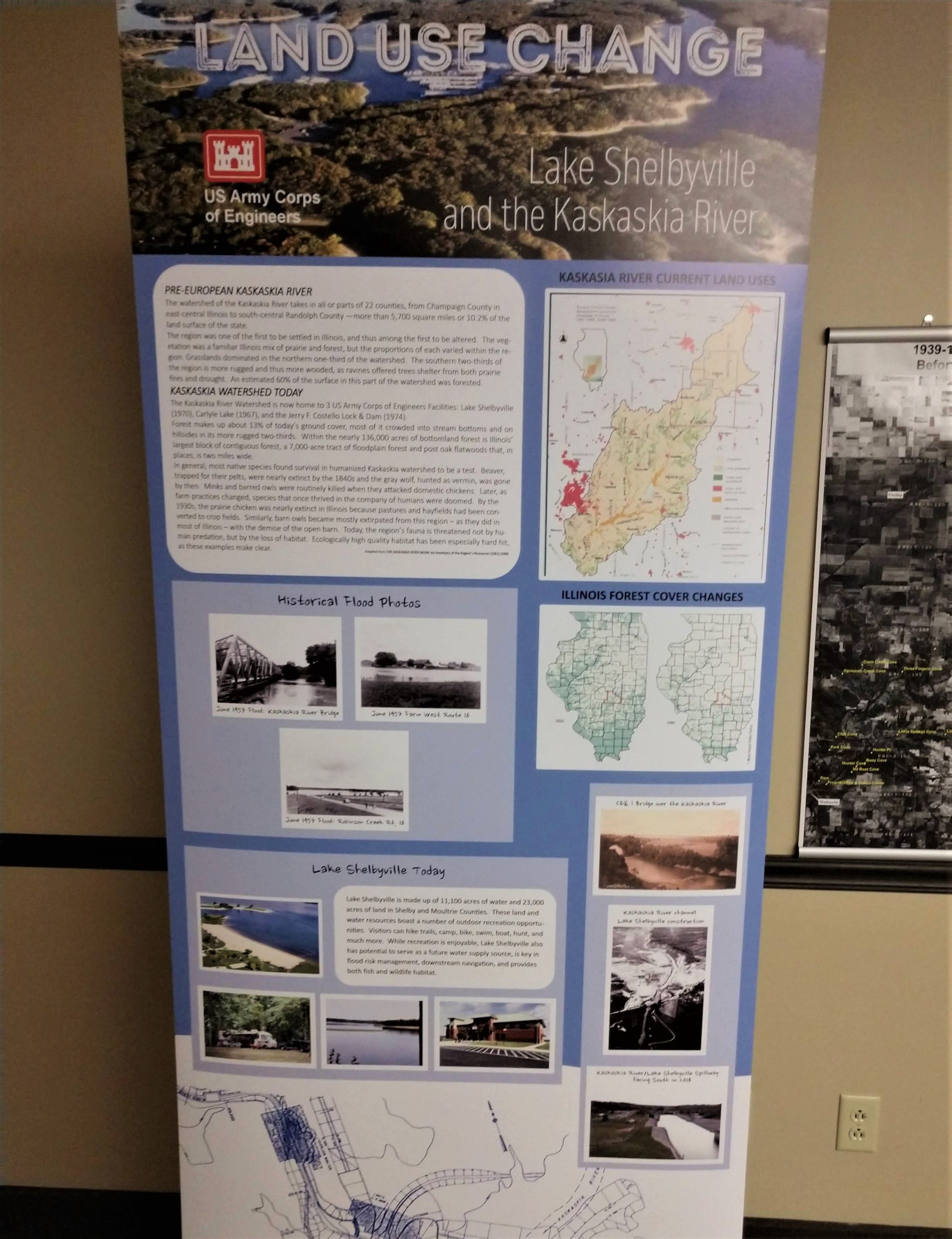
PRE-EUROPEAN KASKASKIA RIVER
The watershed of the Kaskaskia River takes in all or parts of 22 counties, from Champaign County in east-central Illinois to south-central Randolph County – more than 5,700 square miles or 10.2% of the land surface of the state.
The region was one of the first to be settled in Illinois, and thus among the first to be altered. The vegetation was a familiar Illinois mix of prairie and forest, but the proportions of each varied within the region. Grasslands dominated in the northern one-third of the watershed. The southern two-thirds of the region is more rugged and thus more wooded, as ravines offered trees shelter from both prairie fires and drought. An estimated 60% of the surface in this part of the watershed was forested.
KASKASKIA WATERSHED TODAY
The Kaskaskia River Watershed is now home to 3 US Army Corps of Engineers Facilities: Lake Shelbyville (1970), Carlyle Lake (1967), and the Jerry F. Costello Lock & Dam (1974).
Forest makes up about 13% of today’s ground cover, most of it crowded into stream bottoms and on hillsides in its more rugged two-thirds. Within the nearly 136,000 acres of bottomland forest is Illinois’ largest block of contiguous forest, a 7,000-acre tract of floodplain forest and post oak flatwoods that, in places, is two miles wide.
In general, most native species found survival in humanized Kaskaskia watershed to be a test. Beaver, trapped for their pelts, were nearly extinct by the 1840s and the gray wolf, hunted as vermin, was gone by then. Minks and barred owls were routinely killed when they attacked domestic chickens. Later, as farm practices changed, species that once thrived in the company of humans were doomed. By the 1930s, the prairie chicken was nearly extinct in Illinois because pastures and hayfields had been converted to crop fields. Similarly, barn owls became mostly extirpated from this region – as they did in most of Illinois – with the demise of the open barn. Today, the region’s fauna is threatened not by human predation, but by the loss of habitat. Ecologically high quality habitat has been especially hard hit, as these examples make clear. — Adapted from THE KASKASKIA RIVER BASIN: An Inventory of the Region’s Resources (2001)
Historical Flood Photos
Lake Shelbyville Today
Lake Shelbyville is made up of 11,100 acres of water and 23,000 acres of land in Shelby and Moultrie Counties. These land and water resources boast a number of outdoor recreation opportunities. Visitors can hike trails, camp, bike, swim, boat, hunt, and much more. While recreation is enjoyable, Lake Shelbyville also has potential to serve as a future water supply source, is key in flood risk management, downstream navigation, and provides both fish and wildlife habitat.
KASKASKIA RIVER CURRENT LAND USES
ILLINOIS FOREST COVER CHANGES
