DC Quadrants
1 2018-07-15T18:46:59+00:00 Kenton Rambsy 1a8e7c8308fe3da2a51e94dd08e0858bab2a9153 11 1 plain 2018-07-15T18:46:59+00:00 Kenton Rambsy 1a8e7c8308fe3da2a51e94dd08e0858bab2a9153This page is referenced by:
-
1
media/12241.jpg
media/_DAR9034.jpg
2018-06-30T18:21:56+00:00
Understanding D.C.’s Geography
41
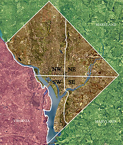
Washington, D.C. has a fairly simple, yet unique layout. The simplest way of reading a map or navigating through the streets of Washington is by understanding that the city is broken into four different sections – known as quadrants – that are divided by using the Capitol building as the center of the four dividing lines.
plain
2018-07-17T12:08:31+00:00
Jones shared his vision for the D.C. he describes Lost in the City. "[P]eople have a very narrow idea of what Washington is like," he says, "[t]hey don't know that it's a place of neighborhoods...and I set out to give a better picture of what the city is like--the other city" (WashingtonPost.com).
Washington, D.C. has a fairly simple, yet unique layout. The simplest way of reading a map or navigating through the streets of Washington is by understanding that the city is broken into four different sections – known as quadrants – that are divided by using the Capitol building as the center of the four dividing lines. Spreading outward from the Capitol, the numbering of street addresses increases number and letter values. (Streets leading north and south increase in value as 1st, 2nd, 3rd Street, etc. Streets leading east and west increase in letter value such as A Street, B Street, C Street, etc.).
While the grid system is relatively self-explanatory, being unfamiliar with the city and layout may prove confusing because of the repeating street names and intersections found in each quadrant. For instance, you could find the intersection of 3rd and L Street in more than one quadrant, each being designated as 3rd and L St. NE, NW, SE, or SW. If unfamiliar with each quadrant, navigating through the streets of Edward P. Jones’ stories might prove confusing. The following are brief descriptions and demographic for each quadrant.
-
1
media/12241.jpg
media/Chapter 2 - Section 2 .jpg
2018-06-30T18:27:13+00:00
Section 2: The Social and Physical Geographies of Washington, D.C.
26
Edward P. Jones’s short stories create a parallel history situated throughout time by immersing his readers within numerous, specific locales and communities across D.C. Jones's work focuses on the people within the city, rather than the history.
image_header
2019-01-28T14:55:41+00:00
Washington, D.C. has a fairly simple, yet unique layout. The simplest way of reading a map or navigating through the streets of Washington is by understanding that the city is broken into four different sections – known as quadrants – that are divided by using the Capitol building as the center of the four dividing lines. Spreading outward from the Capitol, the numbering of street addresses increases number and letter values. (Streets leading north and south increase in value as 1st, 2nd, 3rd Street, etc. Streets leading east and west increase in letter value such as A Street, B Street, C Street, etc.)
While the grid system is relatively self-explanatory, being unfamiliar with the city and layout may prove confusing because of the repeating street names and intersections found in each quadrant. For instance, you could find the intersection of 3rd and L Street in more than one quadrant, each being designated as 3rd and L St. NE, NW, SE, or SW. If unfamiliar with each quadrant, navigating through the streets of Edward P. Jones’ stories might prove confusing. The following are brief descriptions and demographic for each quadrant.